Second Update on Typhoon Wipha and Typhoon Nari – Deadly

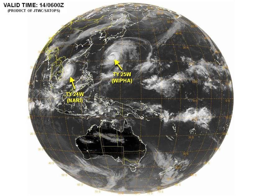
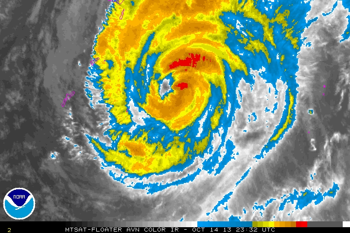
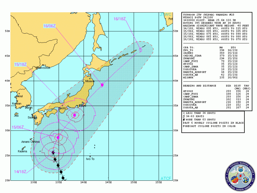
The deadly storms continue to pound the east. Tokyo (CNN) — At least 17 people have died and hundreds of flights have been canceled as Typhoon Wipha pummeled the Tokyo area on Wednesday.

A local government official in Oshima, a small island 120 km (75 miles) south of Tokyo, said that a majority of the people died after heavy rain triggered flooding and landslides that blocked roads and crushed houses. Rescuers were unable to reach about some people in the area hit by landslides.

iReport: Heavy winds near Tokyo as Typhoon Wipha hits

More than 500 domestic and international flights were canceled at Tokyo’s Narita and Haneda airports and the national rail operator halted bullet train services in central and northern Japan. The typhoon is moving north along the Pacific coast of Japan and is expected to reach the northernmost island of Hokkaido by late Wednesday.

Tokyo Electric Power Company (TEPCO), the main electricity supplier in Tokyo and central Japan, said blackouts affected more than 56,000 households. TEPCO, which has been struggling to deal with a series of leaks at its Fukushima Daiichi nuclear plant, said workers at the plant were “on vigil” and accumulated rainwater had been released from storage tanks.

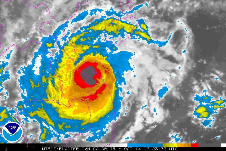
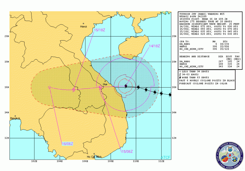
At least 13 people were killed when Typhoon Nari pounded the Philippines over the weekend, the country’s disaster management agency said. The typhoon struck the country’s north Saturday, displacing more than 43,000 people in 11 provinces, the National Disaster Risk Reduction and Management Council said.

131016031257-japan-typhoon-wipha-houses-horizontal-gallery

The deaths reported were due to falling trees, electrocution, mudslides, drowning and collapsed structures, it said. Three fishermen remain missing, and 1,900 passengers are stranded at different ports. Flash floods triggered by the typhoon killed three people and left two others missing in Quang Binh province, provincial disaster official Ngo Duc Song said. The floods submerged 10,000 homes in the province, many of them up to 2 meters (6.5 feet) under water, and left four villages isolated, he said.

Nearly 5,000 people were evacuated from their flooded homes to higher ground, Song said, adding that soldiers and police officers were sent to help villagers deal with the floods. In the neighboring province of Ha Tinh, authorities were searching for three people missing in the floods. The storm weakened to a tropical depression after making landfall in Vietnam.

First Update on Typhoon Wipha

Millions of people in Japan are bracing for the approach of Typhoon Wipha and the expected destructive winds, life-threatening flooding and mudslides. Although Wipha has weakened during the past 24 hours due to interaction with a front to the north, the cyclone remains a dangerous typhoon as it approaches the eastern coastline of Japan.

The cold front mentioned above will continue to direct Wipha northeastward on Tuesday night and Wednesday bringing the center of the storm very close to the coast near Tokyo. The greatest area of concern extends across eastern Honshu, including the greater Tokyo area, home to more than 35 million people.

What is not talked about is that the current track of Wipha takes it right past TEPCO’s Fukishima reactors. In addition to the damaging winds and maybe even a greater concern is the tremendous amount of rainfall expected in that area, up to 250mm. This could prove disastrous in managing the current retention ponds of radioactive wastewaters.

Wipha Track2

Heavy rainfall has already overspread eastern Japan in advance of the storm. Rainfall totals between 150-250 mm (6-10 inches) are expected through midday on Wednesday with isolated amounts over 300 mm (12 inches) before rainfall comes to an end from south to north. Oshima, south of Tokyo has already received more than 558 mm (22 inches) of rain.

rainfall from wipha

The strongest wind gusts are expected to surpass 120 kph (75 mph) during the peak of the storm. Winds of this magnitude can lead to downed trees, widespread power outages and structural damage.

Heavy rainfall will also target the higher terrain of inland Japan. The amount of rain falling on Tuesday night and Wednesday will be significant, enough to cause widespread flooding in addition to the threat for mudslides.

Here We Go Again – Typhoons Alert for Nari and Wipha

The end of this typhoon season in the Pacific is apparently going to be historic. 25 named storms, Phailin was a CAT 5 and possibly the biggest storm on record and now we have TWO more typhoons churning in the Pacific.  Typhoon Nari will impact Vietnam within the next two days as a possible CAT 2 storm and Typhoon Wipha could impact Japan with the next 4 days as a CAT 3-4 storm.

typhoons 14 oct 13

AT 141800Z, TYPHOON 25W (WIPHA) WAS LOCATED NEAR 25.6N 133.9E, APPROXIMATELY 654 NM SOUTH-SOUTHWEST OF YOKOSUKA, JAPAN, AND HAD TRACKED NORTH-NORTHWESTWARD AT 14 KNOTS OVER THE PAST SIX HOURS.  MAXIMUM SUSTAINED SURFACE WINDS WERE ESTIMATED AT 95 KNOTS GUSTING TO 115 KNOTS.

wipha

wipha track

AT 141800Z, TYPHOON 24W (NARI) WAS LOCATED NEAR 16.1N 109.2E, APPROXIMATELY 52 NM EASTWARD OF DA NANG, VIETNAM, AND HAD TRACKED WESTWARD AT 10 KNOTS OVER THE PAST SIX HOURS. MAXIMUM SUSTAINED SURFACE WINDS WERE ESTIMATED AT 75 KNOTS GUSTING TO 90 KNOTS.

nari

Nari's track

  IN ADDITION THERE IS AN AREA OF CONVECTION HAS PERSISTED NEAR 16.1N 151.4E, APPROXIMATELY 405 NM EAST-NORTHEAST OF GUAM. RECENT ANIMATED INFRARED SATELLITE IMAGERY SHOWS DEEP CONVECTION FLARING NEAR A LOW-LEVEL WAVE EVIDENT IN A 142020Z TRMM IMAGE. THE DISTURBANCE CURRENTLY LIES EQUATORWARD OF AN UPPER-LEVEL RIDGE AXIS, IN AN AREA OF MODERATE NORTHEASTERLY VERTICAL WIND SHEAR. HOWEVER, AN ANTICYCLONE IS EXPECTED TO BUILD ALOFT OVER THE NEXT 24 TO 48 HOURS, RELAXING VERTICAL WIND SHEAR AND PROVIDING VERY FAVORABLE UPPER-LEVEL OUTFLOW. MULTIPLE NUMERICAL MODELS INDICATE THAT THE DISTURBANCE WILL CONSOLIDATE INTO A TROPICAL DEPRESSION WITHIN THE NEXT 48 TO 72 HOURS. MAXIMUM SUSTAINED SURFACE WINDS ARE ESTIMATED AT 10 TO 15 KNOTS. MINIMUM SEA LEVEL PRESSURE IS ESTIMATED TO BE NEAR 1008 MB. BASED ON INCREASINGLY FAVORABLE ENVIRONMENTAL CONDITIONS AND MULTIPLE MODEL DEVELOPMENT, THE POTENTIAL FOR DEVELOPMENT OF A SIGNIFICANT TROPICAL CYCLONE WITHIN THE NEXT 24 IS LIKELY.

Heads up to our friends in Vietnam and Japan, it looks like a rocky week. Stay safe. We will update if new developments occur.

Second Update on Typhoons Fitow and Danas –Deadly Storms

The southwest eyewall of Typhoon Danas ripped across the northern tip of Okinawa earlier today. The western Pacific typhoon had peak winds of close to 140 mph, the equivalent of a category 4 hurricane as it battered the Japanese island. Danas will move in a northwesterly direction as it departs the Ryukyu Islands Monday night before then taking a turn toward the north and eventually northeast Tuesday into Wednesday.

danas cat 4

This track will take the center of Danas very close to western Kyushu Tuesday into Tuesday night. During this time the center is expected to remain over water as it passes between Japan and South Korea.

danas Track

Danas will begin to weaken Tuesday into Wednesday as it is pulled north and northeastward by a frontal boundary. This frontal boundary will cause Danas to transition into an extra-tropical system over the Sea of Japan before making a landfall in northern Japan on Wednesday.

Danas will still produce locally damaging winds along with the threat for flooding rainfall and mudslides as it moves across northern Honshu Wednesday into Wednesday night. While Tokyo will dodge the worst of Danas, wind gusts on Wednesday could still top out between 50-65 kph (30-40 mph). Danas will then race east-northeastward away from Japan on Thursday, allowing the country to dry out and recover from any adverse impacts.

Typhoon Fitow has proven deadly as five people were killed and hundreds of thousands evacuated after Typhoon Fitow hit eastern China, destroying houses and farmlands and closing ports and airports. Packing winds up to 151 kms (94 miles) per hour, Fitow hit Fuding city in Fujian province early on Monday before weakening into a tropical storm later in the day, the official Xinhua news agency reported. At least five people have been killed and four others were still missing, Xinhua said on Tuesday. Flight and train services in Zhejiang province, south of Shanghai, were suspended on Monday. In Wenzhou city in Zhejiang province, the storm destroyed over 1,700 houses and 46,800 hectares of crop land, the report said.

fitow track2

So, there is still at least two more days of danger for our Eastern Friends.

New Situation – Another Japanese Quake May Be Possible

As we monitor situations globally certain scientific information rarely reaches MSM.  Such is the case concerning technologies that can predict earthquakes with accuracy.  They do exist and have been known for some time, but not are yet embraced universally in the scientific community.  Never-the-less the anecdotal evidence is over-whelming.  First some background is provided.

Research in earthquake-related electromagnetic phenomena has recently shown that such phenomena make for a promising candidate for short-term earthquake prediction. There is a good deal of accumulated evidence of precursory signatures in a wide frequency range (DC-VHF). ULF geomagnetic change is one of the most promising phenomena and it suggests that short-term prediction is realizable. A new theory of earthquakes (EQs) predicts strong electric discharges which may be detected by a wide-band radio receiving system.

Back in 2004, the French space agency CNES launched a small satellite called DEMETER into polar orbit some 700 km above the Earth’s surface.  DEMETER’s is an unusual mission. Its job is to monitor low frequency radio waves generated by earthquakes.

A group of geoscientists released the data associated with the M 7.0 earthquake that struck Haiti. They say that DEMETER saw a clear increase in ultralow frequency radio waves being emitted from the Earth’s the crust in that region in the build up to the quake.

The anecdotal evidence of electromagnetic effects associated with earthquakes is legion. Various accounts link earthquakes with mysterious light and heating effects. Then there is the widespread evidence that certain animals can sense impending quakes, possibly because of sensitivity to low frequency electric fields.

But good data is hard to come by. Geoscientists have been measuring the currents that flow through Earth beneath our feet for over 100 years. These so-called telluric currents are thought to be generated by friction and piezoelectric effects within rock. And the flow of electrons they cause has been linked to various atmospheric phenomena such as thunderstorms.

But the role these currents play in earthquake physics is unknown. It makes sense that any currents generated by friction and piezoelectric effects should be dramatically influenced by the relative movement of different parts of the crust.

But these effects occur over vast distances and at frequencies that are hard to measure and difficult to separate from background noise. Which is why DEMETER was launched, (DEMETER stands for Detection of Electro-Magnetic Emissions Transmitted from Earthquake Regions).

The results revealed a significant increase of the energy of ULF waves, up to 360%, for a period of one month before the main earthquake compared with the energy of the background,” they say. That’s a dramatic increase. These emissions dropped gradually in the month after the quake.

Dimitar Ouzounov at the NASA Goddard Space Flight Centre in Maryland and a few buddies presented the data from the Great Tohoku earthquake which devastated Japan on 11 March. Their results, although preliminary, are eye-opening.  They say that before the M9 earthquake, the total electron content of the ionosphere increased dramatically over the epicenter, reaching a maximum three days before the quake struck.  At the same time, satellite observations showed a big increase in infrared emissions from above the epicenter, which peaked in the hours before the quake. In other words, the atmosphere was heating up.

Yesterday Hokkaido University stated that there is a possibility that another M9.0 hits north Japan again (soon? imminent?). They say they caught the same earthquake echo of 89.9MHz as what they caught before the March 11th quake. According to their report, another M9.0 may hit from December to January, the epicenter may be from South Miyagi prefecture offshore to Ibaraki offshore, which is beside Fukushima plant.

This is significant enough for us to raise the Pacific quake watch to yellow.  This of course also elevates tsunami watch to yellow in the Hawaiian Islands and along the coasts of Alaska, BC, and the Pacific coastline of the US and Mexico during the warning period.